Live equipment tracking
Shows tractor and vehicle locations in real time and links each machine to its assigned driver and field task.


Agriculture & Farming
An IoT platform that connects tractors, field work, GPS data and local weather monitoring to help farmers and contractors manage large-scale agricultural operations.
Client & project background
The client is an Australian provider of farming software solutions, serving large farmers in Australia and New Zealand. Its team understood farm operations and the coordination problems farmers faced when managing land, machinery and contractors.
Australian farms can range from small fields to several thousand hectares. Mechanisation makes that scale possible, but it also leaves farmers responsible for a large number of machines and widely spread areas of land. Each year, they outsource work such as cultivation and harvesting to specialist farming contractors while retaining responsibility for the land and the progress of the work.
The client wanted to connect these activities in an intelligent farming system: farmers needed to know where each tractor was, which area a driver was working on, how much work had been completed and whether local weather conditions called for a change of plan.
The solution
Shinetech assembled a five-developer team to deliver the software and hardware integration across web, mobile applications and vehicle-mounted equipment. Using GPS, Google Maps and IoT data, the platform connects farmers, contractors, drivers, vehicles, field tasks and weather information in one operational view.
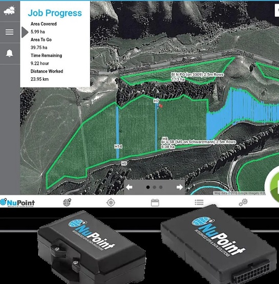
Shows tractor and vehicle locations in real time and links each machine to its assigned driver and field task.
Lets farmers define work areas, monitor agricultural progress and give drivers access to tasks and farm maps from a tablet.
Collects local temperature, wind direction and humidity data to support timely planting and field-work decisions.
Delivery & collaboration
The first version consisted of three connected parts: a web system, an app and hardware. Shinetech assembled five developers to undertake the software and hardware implementation, delivering the first version in three months.
The team used continuous integration and two-week iterations so the client could use and evaluate the software throughout development. Feedback helped the team check whether the functions addressed real business needs and make changes early.
Daily email updates, instant messaging and project-management tools made progress visible. The client could review delivered functions, understand difficulties and coordinate the resources needed to resolve them. Weekly voice conferences provided a regular opportunity to discuss feedback and next steps.
Engineering challenges
The Google Maps integration needed to support marking locations, drawing on maps and performing calculations. These operations were essential to representing farmland and the areas assigned to drivers.
Capturing live GPS data meant handling both accuracy and a large volume of incoming information. The team repeatedly tested and revised the algorithm until the system met end-user requirements.
Direct observation of drivers in the field helped developers understand the farming processes behind each requirement. Technical work and business learning continued together as the team and client worked through challenges throughout the collaboration.
Results & long-term partnership
The initial delivery grew into a collaboration spanning approximately seven to eight years. Beyond the first release, Shinetech worked with the client on refining the platform and developing its capabilities around real farming needs.
Positioning equipment assigned to vehicles and tractors enabled farmers to see their locations through Google Maps, manage drivers' task areas and track agricultural progress. Drivers accessed tasks and farm maps from tablets installed in their tractors, connecting field work with the farmer's operational view.
Local weather stations relayed temperature, wind direction and humidity through the system, helping farmers respond to changing conditions alongside the progress of their field work.
Following the initial release, the team continued optimising the system and developing a second generation focused on farm management in areas with limited or no network signal. The extended partnership gave the team a deeper understanding of the client's product and the working conditions of its users.